Flood Study Program

To date flood studies have been undertaken or are in progress for the following locations:

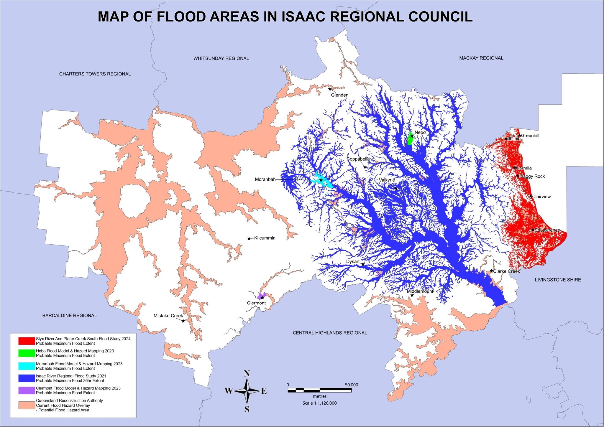
  • Isaac River catchment - the Isaac River Flood Study  was undertaken by KBR and completed in 2021. It covers a large rural area in central Isaac, west of the Connors Range. 

  • Clermont - the Clermont, Flood Model and Hazard Mapping Study  was delivered by GHD in 2023 covers the town of Clermont and its immediate rural areas. 

  • Moranbah - the Moranbah Flood Model and Hazard Mapping Study  was delivered by GHD in 2023 covers the town of Moranbah and extends down to the Peak Downs Highway. 

  • Nebo – the Nebo Flood Model and Hazard Mapping Study  was delivered by GHD in 2023 the town of Nebo. 

  • Isaac Coastal areas – the Styx River and Plane Creek South Flood Study  was delivered by KBR in 2024 and covers the Isaac coastal area, including the communities of Ilbilbie, Greenhill, Carmila, Clairview, Flaggy Rock and St Lawrence.

The below image(PNG, 69KB) shows the extent of flood impacted land (probable maximum flood areas) across the Isaac Region and the relevant flood studies that have been undertaken across these areas. Council will continue to review the extent of our Flood Program in the future.

Flood Study Extents - Isaac Region - Probably Maximum Flood Events.jpg

Isaac River Flood Study

Date of Issue:                  July 2021

Consultant:                     Kellog Brown Root (KBR)

Grant Assistance:         Not applicable

Communities:                Moranbah, Nebo, Dysart, Coppabella

Watercourses:                Isaac River, Connors River, Lotus Creek, Bee Creek, Funnel Creek

Isaac River Flood Study(PDF, 86MB)
View the Study Area(JPG, 3MB)
View interactive flood mapping online

Isaac River - Flood Study Area_page-0001.jpg

Clermont Flood Model and Hazard Mapping Study
Clermont, Moranbah and Nebo Flood Model and Hazard Mapping Study

Date of Issue:              October 2023

Consultant:                  GHD

Grant Assistance:       North Queensland Disaster Mitigation Program (Queensland Government)

Communities:              Clermont

Water Courses:           Sandy Creek and Wolfgang Creek

Documents

View the Clermont Flood Model & Hazard Mapping 2022(PDF, 20MB)
View the Study area(JPG, 7MB)
View interactive flood mapping online

Clermont Flood Study Area_page-0001.jpg  


Moranbah Flood Model and Hazard Mapping Study

Date of Issue:              October 2023

Consultant:                  GHD

Grant Assistance:       North Queensland Disaster Mitigation Program (Queensland Government)

Communities:             Moranbah

Water Courses:           Grosvenor Creek and Isaac River

Documents

View the Moranbah Flood Model & Hazard Mapping 2022(PDF, 30MB)
View the Study Area(JPG, 7MB)
View interactive flood mapping online

Moranbah Flood Study Area_page-0001.jpg


Nebo Flood Model and Hazard Mapping Study

Date of Issue:              October 2023

Consultant:                  GHD

Grant Assistance:       North Queensland Disaster Mitigation Program (Queensland Government)

Communities:             Nebo

Water Courses:          Nebo Creek

Documents

View the Nebo Flood Model & Hazard Mapping 2022(PDF, 23MB)
View the Study Area(JPG, 6MB)
View interactive flood mapping online

Nebo Flood Study Area_page-0001.jpg


Styx River and Plane Creek South Flood Study

Date of Issue:              May 2024

Consultant:                  Kellog Brown Root (KBR)

Grant Assistance:       Preparing Australian Communities – Local Stream (Federal Government)

Communities:              St Lawrence, Clairview, Flaggy Rock, Ilbilbie, Carmila, Greenhill

Water Courses:

  • Styx River with Tooloombah Creek, Deep Creek, Wangrabry Creek and Wellington Creek
  • St Lawrence Creek with Connie Creek and Freshwater Creek
  • Waverley Creek with Amity Creek
  • Clairview Creek with Middle Creek, Colabash Creek and Cattle Creek
  • Plane Creek South sub basin includes Marion Creek, Stony Creek, Gillinbin Creek, West Hill Creel, Spider Creek, Carmila Creek, Flaggy Rock Creek, Oaky Creek and Dry Creek

View the Styx River and Plane Creek South Flood Study(PDF, 192MB)
View the Study Area(JPG, 3MB)
View interactive flood mapping online

Styx River and Plane Creek (South) Flood Study - Study Area.jpg